SATELLITE IMAGE VIDEO

Supplier Details
Chang Guang Satellite Technology Co., Ltd.
Free Member (2023)
[ JiLin, JL,China ]
Business Type: Manufacturer, Wholesaler
Supplier has 5 products
Product Description
Satellite Image Video
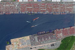
The SP, GF03C and MF satellites of JL1 constellection can gaze at a single target point for 120 seconds at most to record the instantaneous changes of ground objects.
Features of Live Satellite Video of Earth
1
Track the target.
2
Record the track and analyze the situation.
SATELLITE IMAGE VIDEO PARAMETERS
Indicators
Parameter
SP03
SP04-08
GF03C
Substar point ground pixel resolution
Panchromatic:? 0.92 m
Panchromatic:? 1.2 m
Spectral bands
BLUE:410-500nm
GREEN:500-580nm
RED:580-690nm
BULE:437-512nm
GREEN:489-585nm
RED:580-723nm
BLUE:437-512nm
GREEN:489-585nm
RED:580-723nm
Standard scene size at nadir
11 km×4.5km
14.4km×6km
Standard duration
10s; 30s; 60s
Frame rate
5 frame /s
Radiation accuracy
3%
Video image stabilization accuracy
? 0.5 pixel
OTHER JL1 SATELLITES DATA
Night Time Data
Stereo Data
Changguang Jilin 1 satellite constellation is the core project under construction by CGSTL. The first phase of the project consists of 138 high-performance optical remote sensing satellites covering video, high resolution, wide band, infrared, multispectral and other series.
Basic Information
Country:
China
Business Type:
Manufacturer, Wholesaler
Year Established:
2014
Total Employees:
More than 1000
About Us
CGST was founded in December 1st, 2014, it is the first commercial remote sensing satellite company in China. With the total registered capital of 1.97 billion yuan 30.9 millions USD, the company is composed of Jilin provincial government, CIOMP, social capital and technical backbone.On the basis of the integration of satellite-borne”, the integration of airborne” and other core technologies, CGSTL has set up the commercial business dealing with the development and operation of satellite and unmanned aircraft, as well as remote sensing information processing all in one. The main business covers satellite development, satellite in-orbit delivery, satellite component development, mapping services, remote sensing advanced products, industry application solutions, ground application systems, large data application services, etc.
Member History
Year Joined:
2023
Membership Type:
Free Member
Send Supplier a Message
You must be signed in to contact this supplier.